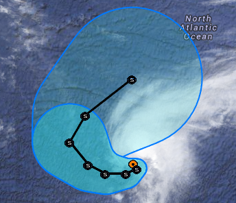
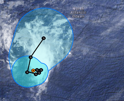
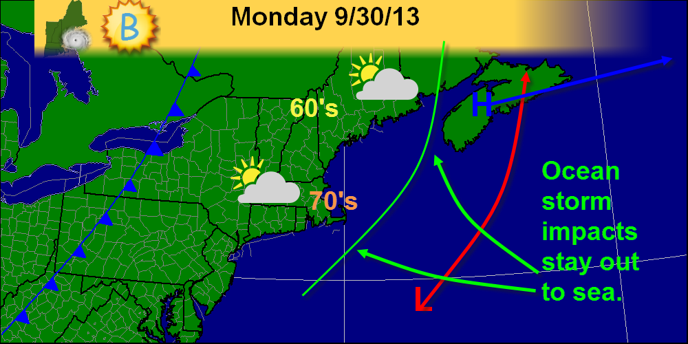
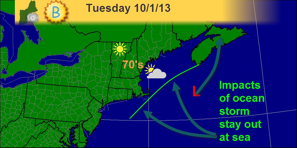
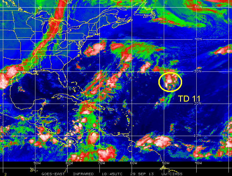
ALTHOUGH CLOUD TOPS HAVE BEEN WARMING RECENTLY...SOME CONVECTIVE BANDING FEATURES HAVE FORMED OVER THE EASTERN SEMICIRCLE OF THE CIRCULATION. THE CENTER IS NOT READILY DISCERNABLE...BUT IS ESTIMATED TO BE LOCATED NEAR THE SOUTHWESTERN EDGE OF THE MAIN CLOUD MASS. DVORAK T-NUMBERS FROM BOTH TAFB AND SAB REMAIN AT 2.5...SO THE ADVISORY INTENSITY IS HELD AT 35 KT. ALTHOUGH THE ENVIRONMENT...IN PARTICULAR THE VERTICAL SHEAR...IS EXPECTED TO BE ONLY MARGINALLY CONDUCIVE FOR INTENSIFICATION OVER THE NEXT SEVERAL DAYS...SOME SLIGHT STRENGTHENING IS POSSIBLE. THIS IS INDICATED IN THE OFFICIAL WIND SPEED FORECAST...WHICH IS CLOSE TO THE MODEL CONSENSUS FOR THE FIRST HALF OF THE FORECAST PERIOD. LATER IN THE PERIOD...THE OFFICIAL FORECAST IS A COMPROMISE BETWEEN THE SEEMINGLY OVER-AGGRESSIVE LGEM AND THE GLOBAL AND HWRF MODELS THAT SHOW DISSIPATION OR A VERY WEAK SYSTEM BY 5 DAYS.
This morning we did have some dense fog. that burned off by about 11:00 this morning. Tomorrow we will see some fog in the morning but that will give way to sun with highs in the 60s in northern Maine with 70s across the rest of New England. Wednesday is also looking nice. More on that forecast coming up tomorrow's blog post
-Bobby Koenig Chief Weather Forecaster, B Weather Weather Forecaster NESU We have a beautiful fall day on tap! The only 2 minor issues will be some morning fog which should burn off quickly, and a few high clouds at the coast. Other than that though, it should be a great day!
-Jack Chief forecaster, NESU Forecaster, Bweather Good Evening Everyone. According to the latest model data Tropical Depression 11 is going nowhere. The Latest Model data shows the Depression going in a loop and then heading northeast as a tropical storm. This season has been fairly quiet. considering last year's storms we are having little activity. With luck the season might pick up. We will continue to watch this storm. -Bobby Koenig
Chief Weather Forecaster, B Weather Weather Forecaster, NESU This upcoming week will be a great week in terms of weather. We have sunny skies, mild temps and a storm-free forecast. Enjoy the beautiful weather!
-Jack Chief forecaster, NESU Forecaster Bweather As the models back off on the storm that we thought was coming the weather get nicer and nicer. The rest of Today will be mostly sunny. Highs in the lower 60s at the coast to the upper 60s inland.
Overnight we received the new model run that starts off each day. In this model run, all the models shifted eastward and formed a tight consensus on track/intensity. Also notice, the models have slowed down just a tad. However, this won't really matter as the storm is not likely to affect even the coast at this point. Just a slight increase in cloudiness and maybe, maybe a shift in winds. The one possible exception would be Cape Cod. That area might receive a brief shower or two but nothing significant for them either. TD 11 in the Atlantic basin- Overnight, TD 11 formed in the Central Atlantic. It is forecast to do a little loop-de-loop then go out to sea. No impacts will be felt here in New England. In fact, before satellites in the 1960's we probably wouldn't of known it was there. Top winds right now are 35mph The minimum pressure is 1010mb It is moving Northeast at 9mph Check our tropical weather resources tab under "Links" above for some sites to get even more information about this storm. I've highlighted TD 11 on this infrared satellite image as it is very hard to figure out where it might be (I had to double check the coordinates because I was unsure). You can clearly see a cold front sweeping across the US as well as (but not as clearly) a trough of low pressure in the Caribbean that will eventually move into the Gulf and hit the Gulf coast, possibly as a tropical entity. We'll have to watch it very carefully as it could cause problems. Even here in New England, the remnants could bring some decent rain.
-Jack Sillin, Chief forecaster, NESU (New England Storm Updates) Forecaster, Bweather Chief writer Forecasterjack The 12z model run shows great disagreement between models as the ocean storm slated to hit Monday approaches. I'll start by going over some of the things that are very clear. -This will not be a significant storm. There is agreement that there will be nothing more than rainy and breezy conditions at the very worst with a much more likely scenario being that the immediate coast gets affected with a band of light rain and breezy conditions. -Timing. There is solid agreement that the rain, if any, will impact the region late Monday into early Tuesday. Not much disagreement on that front. However, the models still have no nail down 2 key aspects of the forecast. -Track. The general consensus it that the storm will come up the coast and move to the SE of the 40N 70W benchmark and then move north or north-northwest towards the Canadian Maritimes. -Intensity. The strength of the low is also very important. The NAM model has a 990mb low where the GFS has a 1008mb low. This ranges from pretty strong to pretty weak. What my forecast calls for. I think a storm of weak intensity will track just SE of the benchmark. It will then move N towards the Maritimes. I think that the only impacts will be a band of light rain affecting the coast and light winds also limited to the coast. This is my forecast for the storm slated to affect coastal areas late Monday.
-Jack Last night, models made no progress in agreeing with one another though one little, important feature was hinted at by nearly all of them. This little feature is a band of rain that is driven off the NW periphery of the low and forms almost its own micro-entity. This is a self sustaining band of precipitation displaced well over 500 miles from the center of the storm and feeds off the energy in the water-like a tropical storm. Another characteristic of tropical cyclones they share is that when they hit land, they dissipate. Unlike tropical cyclones however, they do not have any winds associated with them (any wind is from the low out in the ocean) and they are short-lived like a band of thunderstorms passing through on a summer day. Anyway, the NAM model is by far the most aggressive in terms of both the low development and the band of showers. The GFS brings the band in very weak and puts the low closer to shore but weaker. The euro brings the low farther out than the GFS but stronger and dissipates the band of showers before it reaches the coast. I am going with a GFS/euro hybrid by taking the euro's idea of a stronger low a little farther offshore and combining it with the GFS's idea that the band of showers makes it to the coast. This graphic shows where impacts may occur. I expect the timing of this to be late Monday into early Tuesday
-Jack Another example of the volatility in weather forecasting will unfold early next week. Yesterday, there was good agreement that the ocean storm that we had been monitoring was going to go out to sea. Now the models ore more divided with the Euro taking it farther to the east while the GFS brings it closer to the coast. I chose a track more on the Euro side of things but I brought in a light band of rain as the CMC suggests. The CMC track is closest to where I think it will track. The GFS brings in a band of heavy rain and puts the low in the Gulf of Maine. I do not thinks this is the right idea as the upper level trough thought to help turn the storm to the west likely will not be as strong as the GFS predicts. However, the GFS has been more or less consistent form run to run on this system so that scenario cannot be discounted.
IPCC climate report- The Intergovernmental Panel on Climate Change (IPCC) which is a group of top scientists and policymakers that convene every 5-6 years and produce a 3,000+ page report on climate change. They do this over a period of about a year and the first part of the 2013-2014 report came out early this morning. One key fact it pointed out is that there is a 95% chance humans are causing climate change. Dr. Jeff Masters has a great post summarizing this stage of the report. I encourage everyone, particularly those skeptical of climate change, to look at this article. It’s very informative and sheds light on some of the potential impacts that our energy consumption has on the planet and on civilization. |